Neighboring Cities & Towns
Many thanks to Bill Kombol of Palmer Coking Coal Company for the information he has provided over the years to preserve the history of these areas and especially the coal mines.
Bayne
Bayne was an unincorporated coal mining town that was abandoned after the mine there closed around 1950. It flourished in the early years of the 20th century and by the 1970s largely vanished. It was located east of the Cumberland-Kanasket Road about one mile north of Cumberland. At its peak Bayne boasted more 300 residents, a school, a hotel, a store, 40 homes, and a succession of coal mines. It operated as a company town.
When coal production plummeted in the 1920s, the owners of the Carbon Coal & Clay Co. sold the mines and town to Jim Bolde who assumed operations in 1928. Bolde was a knowledgeable coal miner and good salesman who kept Bayne’s mine going until 1950. That year the mine closed Jim & Rose Bolde so rented began renting homes to loggers, construction workers on the Howard Hanson dam, and others seeking cheap rent. After Jim’s death in 1967, the homes slowly deteriorated and one by one were torn down. Today, only four of the company homes built in 1907 remain.Visit this site to learn more about Bayne.
Bruce
Bruce was a railroad station name located just south of Lake 12 on the Green River Gorge Road. There may have been a station house, but no other facilities. The station was established after the Columbia & Puget Sound Railroad extended a branch line that ran along the south shore of Mud Lake to the Black Diamond Coal Company’s No. 12 mine. It later served Pacific Coast Coal Company’s Mine No. 7 located one-third mile further east. Coal was shipped from Bruce via a railroad branch line that extended from Black Diamond to Bruce, near present day Lake 12. The line was abandoned in 1922.
Cumberland
Cumberland is located about 9 miles NE of Enumclaw on the Vezier Cumberland Road. Originally a mining camp, Cumberland was named by F.X. Schriner in 1893 after the Cumberland coal region of the Appalachian Mountains. Although the mining camps are gone, Cumberland is still a thriving small community located between Nolte State Park and the Kanaskat-Palmer State Park. Several small mines were located nearby including the Navy Mine and the Hyde Mine. The City Hall Saloon and Eatery is a popular stopping spot. Nolte State Park is a superb camping location. Visit this site to learn more about Nolte.
Danville
Danville was located in an area near Ravensdale, located on the south side of the Summit-Landsburg Road near the Landsburg Bridge. Coal was mined there from the late 1890s off and on until the late 1970s. 500 tons of coal was shipped in the first year of the Davis mine’s operation via the Columbia & Puget Sound Railroad’s Danville spur.
After several owners and abandonment, in 1932 the Landsburg Coal Company reopened the mine, but no longer calling it Danville. Over the next years the area became known as it is today “Landsburg.”
In 1937 the Palmer Coking Coal Company reopened the mine and saw a higher production than previous efforts. By the early 1950s coal production had increased to more than 40,000 tons per year. However, as was common, the mine then suffered a series of disasters, including a fire, worker accidents, and structure issues. Two miners, Harry English and Roy Coutts, were on the No. 25 chute when the floor below them sloughed. After eight 24-hour days Coutts was rescued but English was not. Then in 1955 four mines were killed in what is known as the Landsburg cave in. John Kovash, Nathan Russell, Frank Stebly and Louis Vaienti lost their lives. Four headstones server as a monument to those men. The Landsburg mine closed in 1961 having produced nearly 663,000 tons of coal during its 24 years of operation.
Today the Summit Trail Middle School of the Tahoma School District sits on property located just 1/2 mile west of the original Danville mine site.
Durham
Durham is located on the Kanasket-Kangley road, east of Ravensdale. The Durham Colliery was originally organized by Peter Kirk’s Moss Bay Iron & Steel Co in 1886 to supply coal for his planned Kirkland steel mills. Durham was named for a town in Kirk’s native north England. Coal production commenced in 1888 but was shut down within a year. The mine re-opened in 1915 as Durham Colliery Co. The name was changed in 1922 to Morris Bros. Coal Co., changed again in 1932 to Durham Coal Co. and yet again in 1933 to Palmer Coking Coal Co. Durham was on a hillside. At the top of the incline the road turned left for a level stretch, past the mine office and one other house before coming to the hotel. The office was simply one of the company houses that had been converted. A short distance beyond the office was the hotel. It was a large two-story brick building, which also contained a small general store. The mining operators in Durham shut down in 1944. From 1888 to 1944 the Durham mines produced 733,000 tons of coal. Remnants of the town are few. The foundation of the two-story brick hotel and general store do remain.
East Pierce County Towns
Burnett, Carbonado, Fairfax, Manley Moore, Melmont, Montezuma, South Prairie, South Willis, Spiketon, and Wilkeson were established after the Northern Pacific Railroad extended service to east Pierce County and established a growing coal industry. Carbonado and Wilkeson were the most important but all the towns prospered around the turn of the 20th century. Their products, coal, coke, and lumber were overwhelmingly shipped through Tacoma due to the N.P. rail connection.Much of the coal output from east Pierce County was converted to coke for use in the steel industry through a process of heating coal in ovens to drive off volatile gasses such as methane and produce a fuel with a high fixed carbon content. Carbonado was the most productive mining town generally accounting for about 50% of Pierce County’s coal production. Its most important mine was operated by the Carbon Hill Coal Company. Wilkeson was the second biggest producer. As the coal industry declined following World War I, the smaller towns faded and today only South Praire, Burnett, Wilkeson, and Carbonado remain. The area is accessed by State Route 165 which passes through this area on its way to the Carbon River entrance to Mount Rainier National Park.
Elk Coal
This small coal mining town was located near Ravensdale, on the side of the Surgarloaf Mountain, and very close to the also dimly reminded town of Durham. Robert Pearson, an Irish Immigrant, homesteaded the area. The town and the mine were both named Elk Coal. Many locals just call it “Elko.”
Mining started in 1919 in Elk Coal with the first shipments out in 1921. The mine suffered from geologic faulting and this coupled with falling coal prices resulted in failure. In 1928 the mine was taken over by Palmer Coking Coal who did blast down the entrance and part of the mine workings. Going through various leases, it was 1932 when James Bagley and Pete Pergolios took over operations and ran it for nearly two decades as the Big Four Coal Company.
Much more can be learned through Bill Kombol’s article. https://www.historylink.org/File/9419
Hobart
Hobart is one of the few areas that remains with a decent population, 6,767 in 2020, and is continuing to grow. It was settled by loggersin 1879. It remains primarily a rural area. A coal mine operated there until about 1947. The town of Hobart was named in honor of Garret Augustus Hobart, the 24th Vice-President of the United States. The post office opened in 1903 and was operated in a company store owned by the town’s sawmill. The post office operates today as part of the Hobart Food Market, a convenient stop for those traveling from Black Diamond to Issaquah or to connect to Highway 18.
Kanaskat
This are was known best for its small depot on the Northern Pacific Railway, today’s BNSF Railway. It served as a water-stop for the steam-powered trains coming through.In 1900 the NP built a 2,850 foot passing track, a 1,200 foot house track, a wye connection with the Green River Branch to Kangley, Selleck, Barneston and Kerriston, a fourth class combination station, a second class section house, a 24-man bunkhouse, a double tool house, and a box water stand and standpipe. The ornate Victorian Station was burned to the ground in 1944. It wa replaced by a round-roof box car, and after WWII that was replaced with a solid brick station. In 1949 the US Army Corps of Engineers built another station. Thus the Kanaskat had the dubious honor of being home to four stations in 90 years! Kanaskat (or Kanasket) was named after a chief of the Klickitat people. The Kanaskat-Palmer State Park is nearby.
Krain
Today the name “Krain” is often associated with the locally well-known Krain Corner Cafe, still serving up delicious meals. The area is often also called the “Krain Corner” where the intersection of Highway 169 and SE 400th St meet south of Black Diamond toward Enumclaw. It is also known for the nearby Holy Family Krain Cemetery which dates back to at least 1901.
In its early days the Cafe was known as the Krain Corner Tavern, a favorite local watering-hole.
Early settlers to the area came from Austria and Yugoslavia. The name “Krain” in Austrian means “foot of the hill.” The mean either worked in the mines or with timber. It survived as a town from the early 1880s into the 1930’s but gradually disappeared with the incorporation of Black Diamond and Enumclaw.
For more about Krain: https://blackdiamondhistory.wordpress.com/2023/02/06/restaurant-and-cemetery-all-thats-left-of-krain/
Kummer
Those traveling from Black Diamond to Enumclaw will cross over the Kummer Bridge built in 1932, now officially known as the Dan Evans Bridge, but still “the Kummer” to locals. The Kummer area was best known for its clay mines, used in paving and building bricks. The town was named for George Kummer, a ceramist and engineer for the Denny Clay Company. Read the full story by Barbara Nilson and Bill Kombol here.
Lawson
Today we are more familiar with Lawson Hill, running eastward from Highway 169 at the intersection of the Cenex Station. Lawson was a once bustling community located in this area. The mine was founded by Eugene Lawson. It was established in 1896 as a coal mining town when the mine was founded by Eugene Lawson. Unfortunately on the morning of November 6, 1910 an explosion killed 16 miners. The bodies of 11 men were brought up, while 5 were unable to be recovered. The disaster brought the community to a heart-breaking end. Today some remains can be viewed but they are on private land.
Maple Valley
Black Diamond is surrounded by many neighboring cities and towns with their own historic significance. Many of these historically had either coal or clay mines. The Society has maintained several documents of the history of those areas.The largest of those is Maple Valley, just to the north of Black Diamond. It was originally settled in 1879 by three men who were improving a trail and brought their families to live here. The town’s early history had to do with lumber, coal and the railroad that ran through it from Seattle to Black Diamond.
You can visit these websites to learn more:
Maple Valley Black Diamond Chamber of Commerce
Navy
Navy was a small town near Cumberland that sprouted with the opening of the Navy mine. Recently it is more well-known for a fire that broke out at the abandoned mine on June 5, 2023. It was thought the fire smoldering was from within the coal tailings. It took eight weeks to contain the fire.
Palmer
Palmer was another old railroad town that originally served as a telegraph station. It was named for George L. Paolmer, a timberman. It once thrived across the Green River from Kanaskat.
Apparently, the post office located in Palmer burned and the authorities moved it to Kanaskat but left the name of Palmer. Another story says that by the early 1920s, population had declined in Palmer to the point that the post office was moved to Kanaskat; but there was so much red tape involved in establishing a new post office and closing out the old one, that the Palmer designation was retained though the building came to Kanaskat. Now residents pick up their mail in several metal boxes or have it delivered from Ravensdale. Cite.
Selleck
Selleck originated as the company town of Pacific States Lumber in 1916, under the supervision of Frank Selleck. In its early years it was well-known for its lumber mill which played a role in the rebuilding of Tokyo after the 1923 earthquake At that time a community of Japanese workers and family came to reside in Selleck. Their area was called “Lavender Town” after the owner of a local saloon and general store. Today the only visible indication of their residence is a pond landscaped with bamboo.
At its peak Selleck’s population was 900 and included a school, hospital, 2 hotels, a community hall, several lumber mills and several stores. Pacific States Lumber declared bankruptcy in 1939 which ended growth in the area. If you visit the area today you can still see the Selleck school and some remains of the former community hall, as well as several businesses that remain active and popular, including the City Hall, a well-known tavern.
Taylor
Now extinct Taylor began in 1893 as a company town for the Denny Clay Company. It was well-known for clay mining and the Denny Clay Company both mined clay and produced clay products. A railway was brought into Taylor in 1892 which allowed the clay business to boom. The town did have a hotel, saloon and a post office called Taylor that remained in operation until 1944.
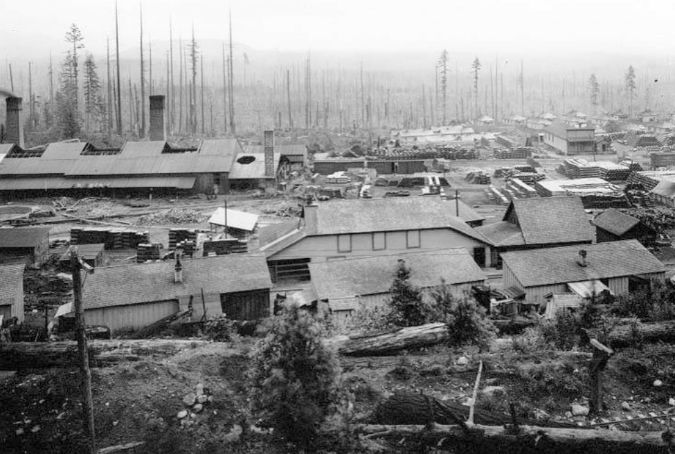
Shown here is the Denny-Renton Clay and Coal Company Brick and Tile Plan at Taylor. Asahel Curtis Photograph
Get Railroad & Mines Maps
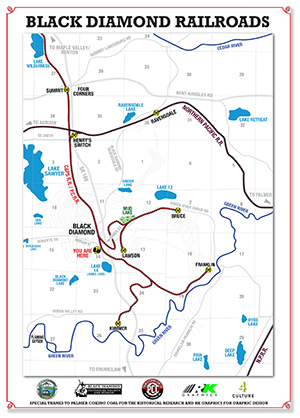
Railroads Map
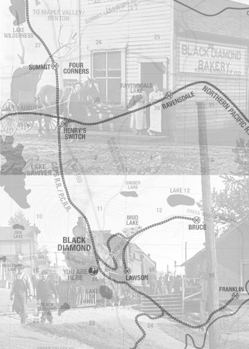
Our new Railroads Map outlines the routes, railroad companies, and provides a detailed timeline from 1873 – 1991. Grab the map and start exploring the history and impact railroads had on the coal industry, businesses and families living in Black Diamond, WA.
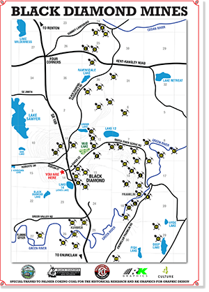
Mines Map
Stop by the museum or download our new Black Diamond WA Mines Map. This detailed map features Mines Pre-1945 and Post 1945. Over 45 mines scattered Black Diamond providing families with work, business with customers and the country with coal.
